What did I do this summer? I worked. A lot. And when I wasn’t working, I was practicing. A lot. My car died and left me
stranded in Utah, and my dog, motorcycle, trailer, stuff and I hitched* a ride in an un-air-conditioned van with only one operating window to get home to Tucson.
My dog passed on to greener pastures soon after our return (not due to the hot as hell journey, for the record), and one of my jobs got really wonky, which is going to make the next eight months a real challenge. (I am vehemently - and I mean vehemently! - opposed to my new and highly unimproved seven day work week.) Not the best summer, I’d say, but there was one wonderfully bright spot. One precious four day respite where I packed in 800 miles on two wheels, 27 miles on two feet, 1028 river crossings (approx) and 1 scratched camera lens. Go big or go home, don't you think?
Zion National Park!
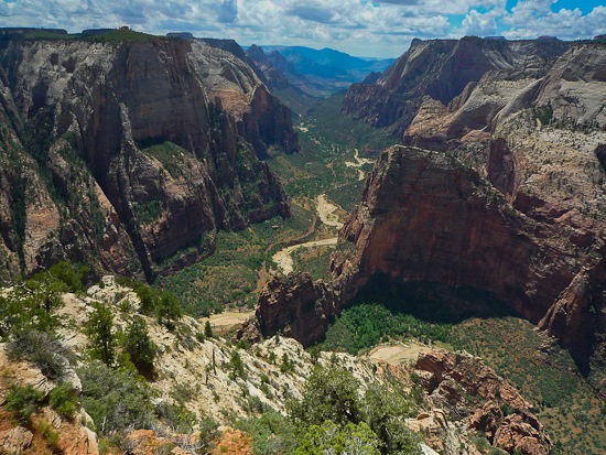 |
| Inspiration Point |
No doubt the rain opened up a few campsites. Usually the park is full for the months of July and August, but we were lucky and secured walk-in a spot (late in the afternoon, even!) at South Campground.
 |
| Riding Hwy 9 (Mount Carmel-Zion Highway) again. Unlike last year, this year I was allowed to stop and take pictures. Except I didn’t. Because it was raining. |
After setting up camp, we stretched our legs in the drizzle on a short hike to the Emerald Pools. The pain you feel upon discovering your camera lens is fatally scratched is directly proportional to the grandeur of your location. Ouch. I’m glad I had a little back up Lumix in my tank bag.
 |
| Dusk on the Kayenta trail, as we return from the Emerald Pools. The pools weren't so emerald in the rain. |
Good morning, Ducati! Time to hike to Inspiration Point (shown in the first photo of this post.)

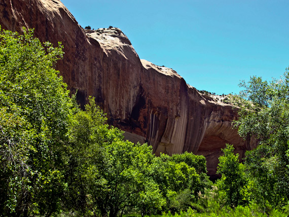
We got a little off trail here, but it was worth the trouble. I thought the only place you saw stuff like this was the cover of Utah guidebooks. Magical to see it for real!

We sacrificed a chance to hike to the famous (and treacherous, I'm told!) Angel’s Landing that afternoon to complete preparations for the next day, our one chance to tackle “The Narrows – Top Down.” Listed as one of National Geographic’s “America’s Best 100 Adventures,” this 16 mile river trek brings the hiker down the Virgin River, through graceful pastures, by spouting springs, past waterfalls and hanging gardens, and into majestic and mysterious narrow gorges with walls soaring up to 2000 feet overhead. The slot canyon sections (marked on our map in a caution tape shade of yellow as "NO WAY OUT!") meant that flash flooding could be a real danger. I was only willing to attempt it if the flash flood potential rating was “low”. A hopeful inquiry at the back country permit office revealed that it was high today, medium two days later, and on the day we had designated for the expedition… low! We slapped down ten dollars for our back country permit and took some time to strategize our gear and transportation. Dry bags, shuttles, and enough food to get me to the moon and back (plus a little extra).
Food find! The Springdale Candy Company is a cut above your typical country fudge shack. As a reward for our research and prep, we took critical tastebuds to dried apricots, candied oranges and candied ginger, all covered in lustrous velvety smooth chocolate. We absolutely could not pick a favorite.
 |
| Quality stuff |
Well before dawn, we stumbled and yawned by the light of headlamp about a mile to our shuttle. It stung us more than a little, but logistics did not allow for the two motorcycle arrangement (the hike is not a loop), so we reserved shuttle seats with the Zion Adventure Company. With a bit of a shrug, we rented the strongly recommended neoprene socks (to wear with our hiking sandals) and hiking sticks. The ride to our starting point of Chamberlain Ranch would take an hour and a half, consuming precious daylight, if the shuttle could make it through the slippery mud at all. If not, no hike for us!
We hit the trail and cautiously dipped toes into the gently flowing stream… HaHA! We are INVINCIBLE! The All Powerful neoprene socks protected us from cold water, sharp rocks, flash floods*... even my pedicure handily survived the assault of 16 miles of toe bashing. And my hiking stick? How I HATE YOU. Must I drag you along for the entire day? I considered abandoning it, and paying a fee for its, um, "loss."
 |
| We begin in gently rambling pastureland. The value of the neoprene socks was made immediately clear. The powers of the hiking stick would be revealed later. |
In order to find the smoothest route, we crossed the river more times than we could count. I wonder if the 16 mile estimate takes this into account.
 |
| Not too deep here. Yet. Even so, I was beginning to suspect that stick was going to make itself useful. The method? Plant stick against current, stumble, stumble. Plant stick against current, stumble, stumble. Lather, rinse, repeat. Approximately 1028 times. |
 |
| Pretty deep here! I do believe I was being washed away towards a small but threatening waterfall (not shown). I can thank my hiking partner for photographing the moment. As you can see, real dry bags are essential equipment. A zip lock bag is not going to do the job. We had to swim a number of times. |
And after we made our first really deep, really serious, perhaps even a teensy bit scary river crossing? Oh, hiking stick! Where have you been all my life?
 |
| Bestowing blessings upon the previously despised hiking stick at the end of the day. We were told that trekking poles would not survive the trip, and when we got to the end of our hike, we believed. |
I do believe I have never been on a more simultaneously awe-inspiring and heart breaking hike. This is truly the stuff that defines our American West - grand and wild, and achingly beautiful. Yet we had so little time to sit back with mouths agape at the wonder of it all. As we calculated our progress using landmarks and a timeline, we soon realized that if we continued to hike without stopping we would (hopefully) reach Sinawava Point (the end of the trek and the northern most shuttle stop in the park) around sunset. Pause to unpack the 2lb (that doesn’t count the lenses!) dSLR camera I had been lugging (not mine), along with the necessary tripod (the low light conditions of a slot canyon really demand one) and we’d be bumbling over that tricky terrain in the dark. No thanks.
Press on, press on! And so we did, snapping grainy, blurry photos in the few moments that were not fully occupied with river crossings and unstable footing, using the waterproof camera (also not mine) attached to my pack by a retractable lanyard. Thank goodness for that!
 |
| Constraints of time, equipment (because we didn’t have time to unpack the drybags that held the good stuff) and light really hampered our ability to capture this spectacular place on film. This photo comes close, though, which is why it is one of my favorites. |
Even though we breezily complete mountain hikes in half the published projected time, this hike humbled us like no other. Slogging almost the entire 16 miles through a rushing river and over slippery rocks and boulders (there is no actual “trail”) is slow going and hard work. And, (what luck!), the usually clear water was muddied from the rain in the days before, making all those algae covered stones invisible. We had to test the depth of the water and find secure footholds for each step by feel using our feet and hiking sticks. The river flow that day, measured at 81 cfs,*** was enough for me. We found ourselves neck deep (or swimming) plenty of times and I was, quite frankly, simply washed away by the current more than once. In the end, we would need every minute of the listed 12 1/2 hours for our journey, and surely would not have emerged before dark without the aid of our hiking sticks. Although completing this trek in one day felt like a lifetime accomplishment, I don’t recommend it as the best way to appreciate its richness. If time had allowed, it would have been far better to make use of one of the back country campsites along the way, allowing two full days to explore this magical route. Next time, (the more I do, the more my “to do” list grows!) I’ll hike in and back out from the south end, covering far fewer miles yet somehow seeing much so much more. And that would leave me just about enough time to take in Angel's Landing, too, no?
*Okay, “hitched” gives the wrong impression. The driver of said van was caravaning with me to begin with.
**Not really.
*** Cubic Feet per Second. Anything under 70 is considered ideal or “easy,” 80 is on the upper end of “mild" (good grief, knowing what I know now, I wouldn’t sign up for the “moderate” rating of 100 cfs), and thru permits (needed to hike “Top-Down,” as we did) are not issued at flows greater than 120 cfs. The average for the month of August is about 50 cfs.


")
")
")
")
")
")
")
")

")
")


